The main island of Okinawa is home to well over a hundred world-class beaches which are renowned for their crystal clear water, beautiful white sand and coral reefs making the prefecture one of the most popular summer holiday destinations in Japan.
When planning a trip to the Ryukyu Islands, you are certainly spoiled for choice when it comes to making a decision about where you’re going to go for a bit of outdoor activity. With such a large number to choose from, there are obviously going to be some pros and cons for each that should assist you with your decision making process.
When it came to the planning for this trip, we had quite a few options as well as quite a few suggestions from friends who had already visited Okinawa. So when it came time to decided where we’d be slumming it on the beach, we made sure that the ones we chose fit into our long list of places that we wanted to visit.
In the end we chose two very different beaches, one of Okinawa’s most popular, namely Manza Beach (万座ビーチ) and another that was relatively secluded on a distant outlying island. Fortunately the latter ended up being the best as the beach we chose to go swimming at wasn’t jam-packed with people and the experience was absolutely fantastic.
Today’s post is about our day trip to northern Okinawa’s outlying Kouri Island (古宇利島), which is connected to the rest of Okinawa by an almost two kilometre bridge. Our trip to the island would not just include swimming at Kouri Beach, but the popular Kouri Ocean Tower and the picturesque ‘Heart Rocks’ as well.
Kouri Island (古宇利島)
Kouri Island, located just off the north-western area of the main island of Okinawa was officially connected to the rest of Okinawa in 2005 through a series of bridges. The first bridge takes you from the main island to Yagaji Island (屋我地島) and then from there you cross the beautiful Kouri Bridge - the longest bridge of its kind in the Ryukyus.
The small island, circular in shape has a radius of about 1km and features an 8km road that encircles the island. It is also home to a large population of about 350 people.
Since becoming accessible by car, the island has transformed into a popular destination for both local and foreign travelers who brave the ninety minute drive out of the capital to enjoy the beautiful beaches and crystal clear emerald waters.
Most visitors to the island are likely to opt for driving around the island, and admittedly that is what we did, but if you visit, I would recommend parking your car at the free parking lot on the Kouri side of the bridge, renting a bicycle and enjoying the beauty of the island at your own pace. The thing about Kouri island is that it is small, and so are the roads, so if you see something beautiful, you’re unable to stop to take photos.
Likewise you can’t stop on the bridge, but if you’re on a bicycle, you can easily stop to enjoy much better views of the bridge and you might even be lucky enough to see sea turtles swimming by in the water below.
In retrospect, I wish I had of done a bicycle tour - the weather however wasn’t cooperating for most of the trip.
For most tourists, the beautiful beaches are enough reason to visit the island, but for the local Ryukyuan people, the island has been long regarded as the ‘Island of Love’ by the local Ryukyuan people.
Legends claim that the Okinawan version of ‘Adam and Eve’, ‘Uminai’ and ‘Umiki’, lived alone in a cave on the island before having children who eventually spread to the rest of the islands.
Thanks to the legend, Kouri Island has always been a popular destination for couples, especially to visit the Heart Rocks and the cave where Uminai and Umiki were thought to have lived thousands of years ago.
The local economy also caters quite a bit to the notion of the island being a romantic one with picturesque chapels set up to host weddings while overlooking the beautiful ocean and landscape of the island.
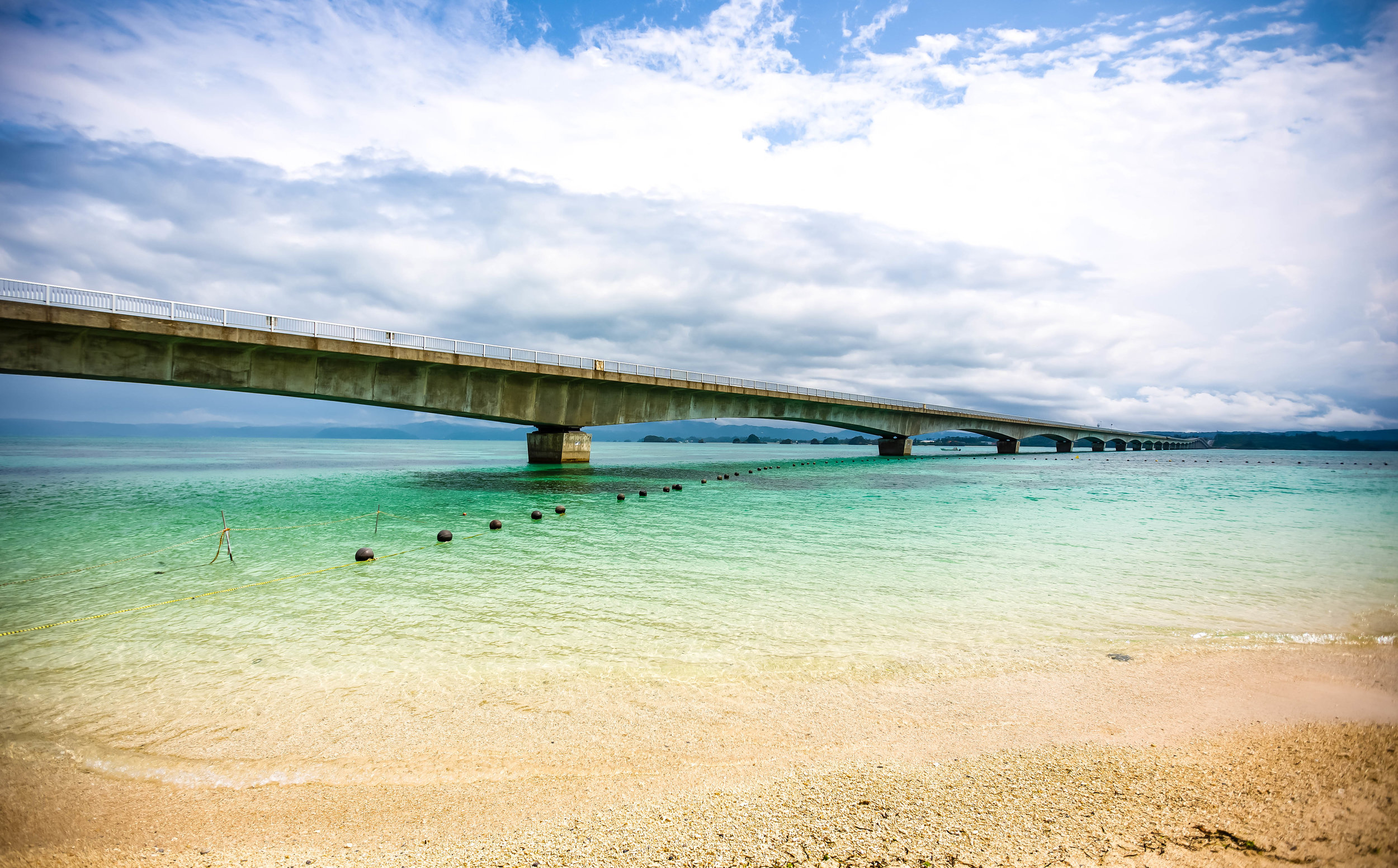
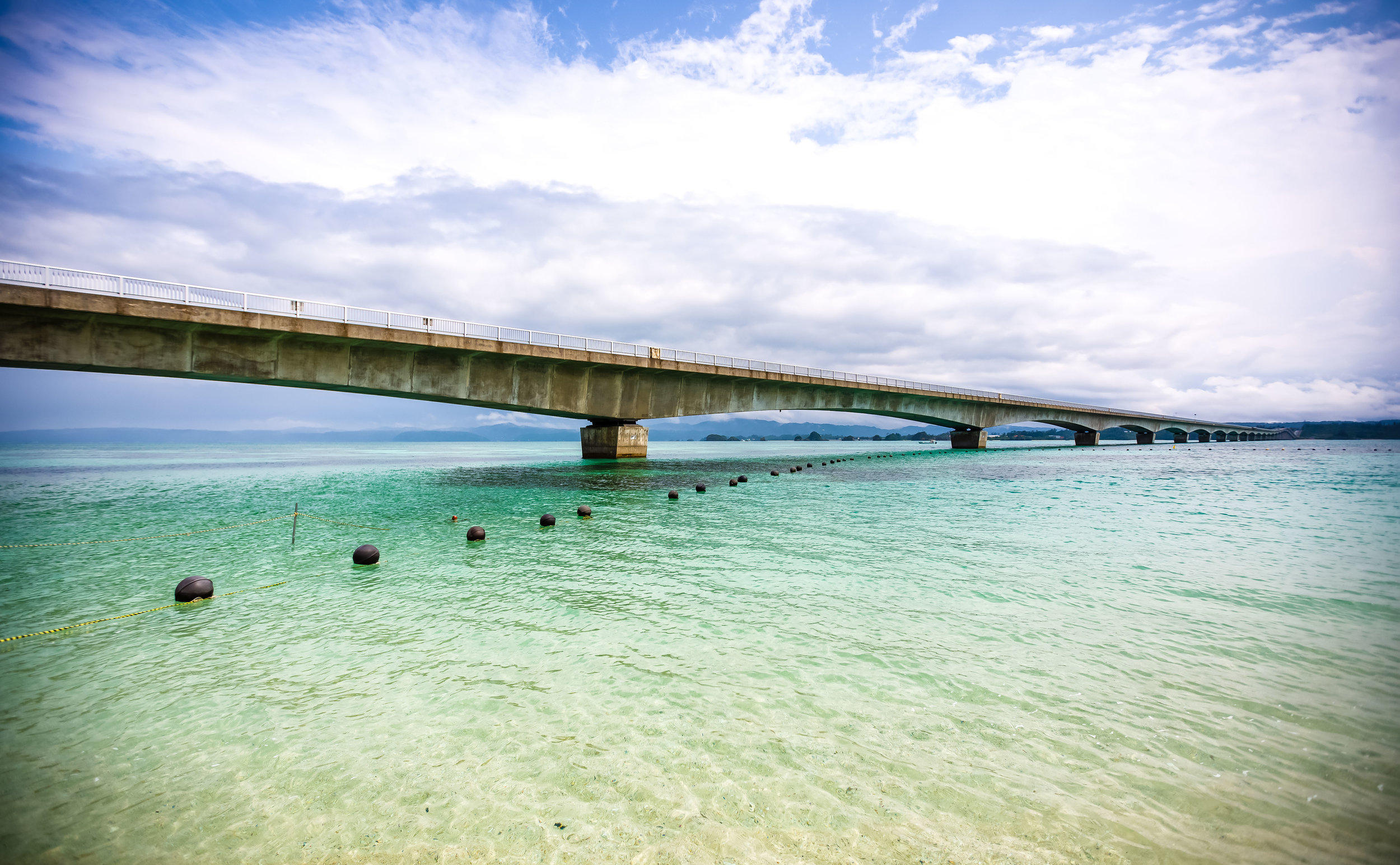
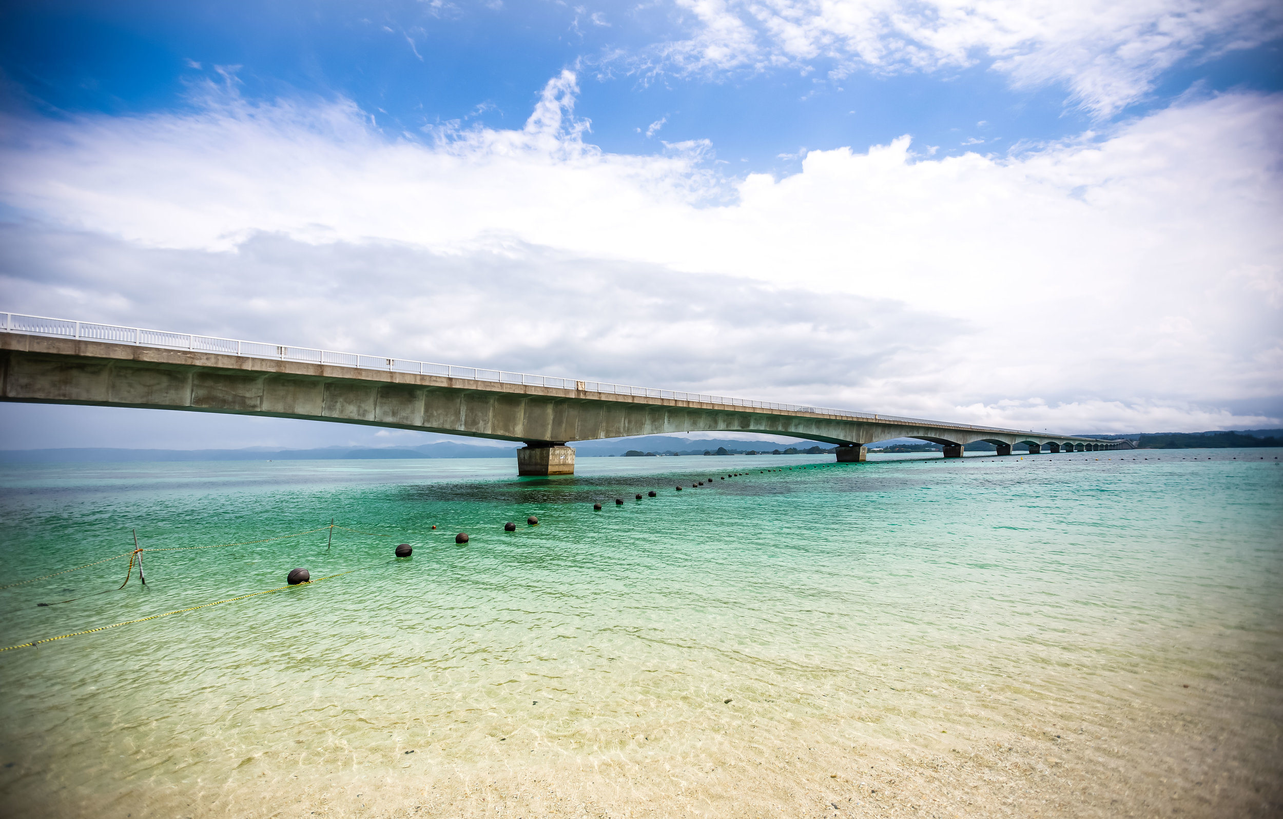
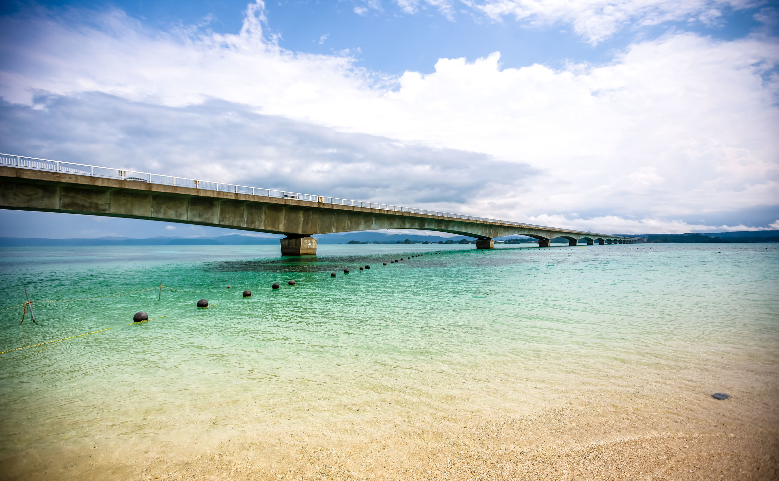
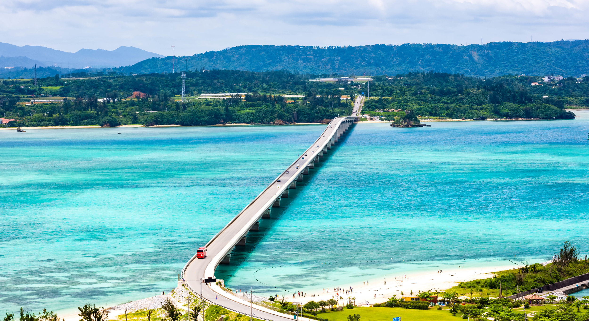
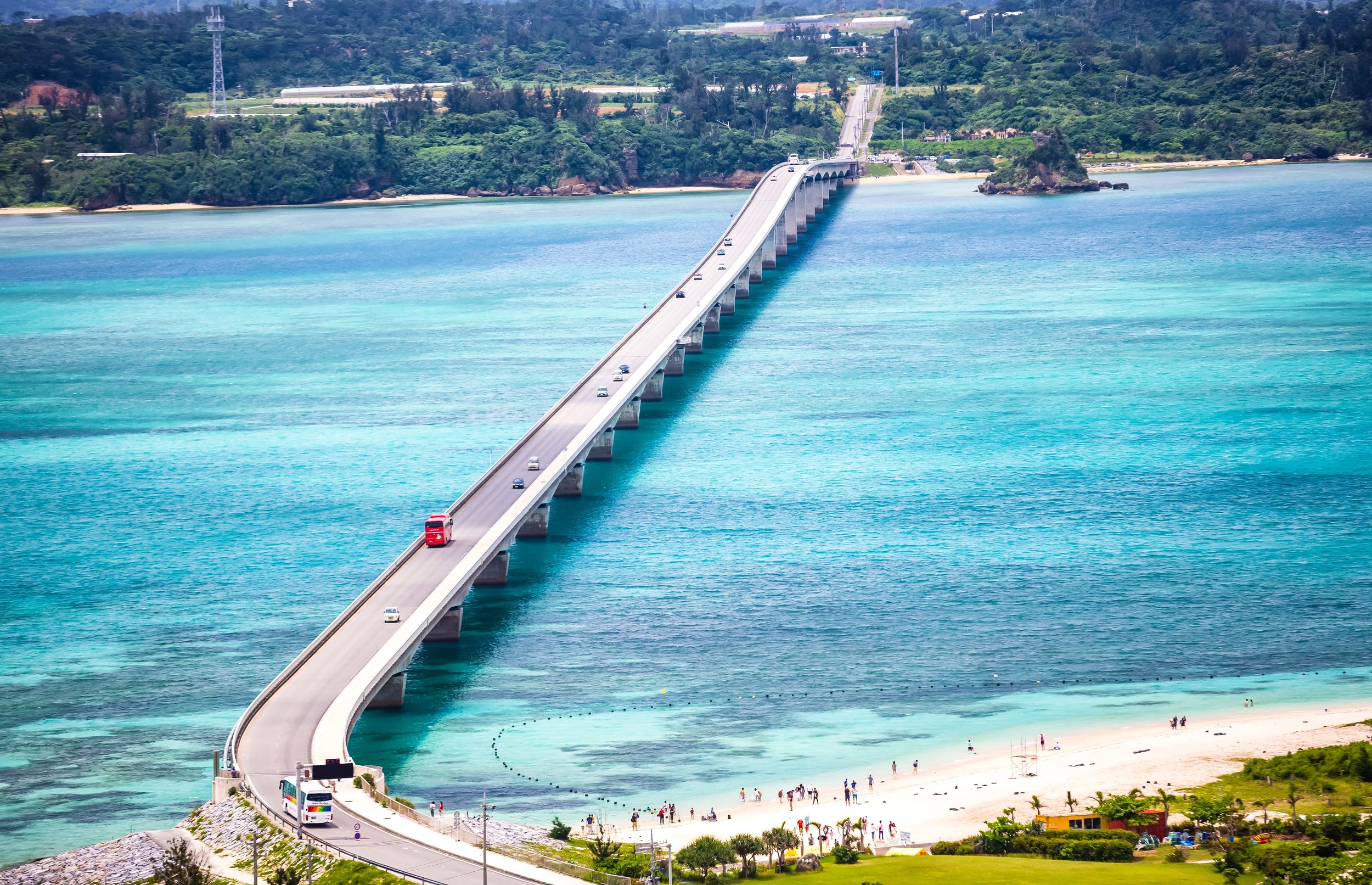
Kouri Bridge / Beach
Coincidentally one of the main attractions on Kouri Island is the bridge that connects the island to Yagaji Island and the rest of Okinawa. Completed in 2005, the nearly 2,000 meter long bridge is the longest (toll free) bridge in Japan and might arguably be one of the most beautiful in the country.
If you are visiting on a sunny day you are going to be in for a real treat as you approach the bridge.
Knowing this, I had anticipated our arrival and patiently watched the GPS in our rental car as we passed through farmland on Yagaji Island. As we approached, the sky suddenly became a lot wider and when we started to drive up an incline, it signalled our arrival at the bridge. I could hardly believe my eyes looking out the window on all sides of the car as the colours in front of us were spectacular - The clear blue sky in addition to the emerald green sea looked amazing and instantly reminded me of my trip to Palau a few years prior.
The 1,960 meter long bridge doesn’t take much time to cross, but you’ll likely notice that people start driving considerably slower when they’re on it. This is because the scenery is so stunning that its hard to concentrate on driving while feasting your eyes on the panoramic landscape in front of you. Unfortunately you can’t stop your car on the bridge, but you are able to walk or ride a bicycle across it, so if you have the chance, I recommend trying one of those.
Once you cross the bridge you are immediately met with Kouri Beach and the Kouri Island Market (古宇利市場) where you’ll find free parking, bike rentals, coffee shops, restaurants and (most importantly) Blue Seal Ice cream vendors. There are also changing rooms and shower facilities for those who visit the beach.
While others might enjoy some of Kouri Islands other attractions, Kouri Beach (古宇利ビーチ) would turn out to be the highlight of the trip for me. When we arrived at the beach, it was just after a downpour and most of the people had already left, so we pretty much had the place entirely to ourselves. I took that opportunity to first take some photos of the beach without a bunch of tourists blocking the view. Afterwards, I returned to the car, put all my camera gear away and returned to the beach for a swim.
The water at Kouri Beach is crystal clear, warm, deep enough for a real swim and doesn’t have any strong currents that could prove dangerous. It was an absolute pleasure to swim around in the water for an hour before getting back in the car and heading back to Naha.
As I mentioned above, you’re spoiled for choice when it comes to beaches in Okinawa, but the beautiful water, fine white sand and the addition of the picturesque bridge make Kouri Beach an ideal one if you’re looking for a place to swim for the day.
Kouri Ocean Tower (古宇利海洋塔)
The Kouri Ocean Tower is a multi-faceted tourist attraction located a short distance away from Kouri Beach. The tower opened in 2013, shortly after the completion of the bridge and consists of an observation tower, sea shell exhibition, restaurant, souvenir shop and a chapel and well.. not much else.
After paying an admission fee of ¥800, you are ushered into a narrow path where you’ll line up for driverless carts that will transport you further up the hill to the entrance of the tower. While riding up to the top you’ll probably enjoy yourself as you’re being transported through a beautifully maintained tropical garden.
Once you pass through the doors you are immediately met with a sea shell museum that is out of this world. I mean, if you’re into seashells that is.
If you’re like me and you don’t particularly care much about sea shells, you’ll probably go straight for the elevator that will take you to the main attraction, the observation platform in the tower. The first platform is on the interior and is covered with glass on all sides allowing for excellent panoramic views of the bridge and the ocean. The thing is though, taking photos through glass isn’t preferable, so you’ll probably want to make your way to the top of the tower where there is a giant bell (that annoying tourists will definitely ring as if climbing a flight of stairs is an accomplishment) and a 360 degree view of the island.
The view from the tower is beautiful and you get to have a birds eye view of the bridge and the ocean, but I’m not really sure that the price of admission is really worth the experience.
I would have preferred to instead use that money to rent a bike and ride around the island.
But hey, if you’re interested in sea shells, you’re certainly going to enjoy the large display.
Once you’re done with the tower, you’ll make your way towards the exit where you’ll have to pass through a souvenir shop where you’re able to purchase lots of Okinawa Omiyage (souvenirs). I don’t usually fall for these kinds of tourist traps, but I tried a couple of pineapple sparking wines that were locally made and were quite tasty, so I bought a couple of bottles to bring back to Taiwan.
A few days later though when we were doing our last minute shopping we found the same bottles on the International Shopping Street in Naha for a fraction of the price.
If you visit the Ocean Tower, you’ll definitely be able to enjoy the view from the tower, but I don’t really feel like there is much else there that warrants much of your time.
Link: Kouri Ocean Tower


Heart Rocks (ハートロック)
Our excursion to the Kouri Island ‘Heart Rocks’ turned out to be quite an interesting experience.
Before I get into that though, I think I should mention a minor pet peeve of mine - Here in Taiwan (where I live), people often visit locations with rocks that they claim look like something.
For example: Rocks that look like animals, gods, people, etc.
I’ve never been a fan of this kind of stuff, and friends insist that I have a don’t have much of an imagination, but I don’t really understand the attraction. Nevertheless you can’t go to Kouri Island and not see the Heart Rocks, so I went along for the ride and tried my best not to complain.
When you get close to where the Heart Rocks are, you’ll find several parking lots set up where you’ll have to pay a fee to park your car and use the trail to the beach. The parking lots are a bit of a tourist trap, and the closer the parking lot is to the beach the more you’re going to have to pay.
You can’t just leave your car on the side of the road, so you’re more or less forced to pay the fee.
Once you’ve parked, it is a short walk down a trail to the beach where you’ll find a small coral beach with the famed Heart Rocks protruding out of the ocean. The rocks, which I suppose you could say look like hearts are quite picturesque and you’ll find quite a few people lining up to get photos in front of them.
The area has always been well known with locals, but rose to fame in recent years thanks to the Japanese boy band, Arashi who shot an airline commercial with the rocks as a backdrop. This brought the existence of the rocks into popular culture and ever since then, the area has become a popular stop for Japanese and Taiwanese tourists who insist the location is romantic.
While we were taking photos of the rocks, the weather took a turn for the worse and a light drizzle of rain forced most of the other tourists to leave. We thought of this as an opportunity to take some nicer photos so we stayed for a bit. Unfortunately that light drizzle turned into a torrential downpour of biblical proportions and we had to take cover in one of the caves to wait out the storm.
For most people a visit to the ‘Heart Rocks’ is a romantic experience, because, well, the rocks look like hearts. For me though, as I sat there huddled inside a cave during a torrential downpour, all I could think of was that the terrible weather probably meant that I wasn’t going to be able to go swimming at Kouri Beach.
Fortunately after about half an hour of waiting for the rain to stop, it finally did and we made our way back to the car to change out of our wet clothes and dry off.
If you love rock formations, then yeah, a visit to the Heart Rocks is going to be a rewarding experience. Even if you don’t though, if you find yourself on Kouri Island, you should probably stop by for a short visit because this beach is quite picturesque.


Getting There
If you’ve rented a car for the duration of your travels in Okinawa, getting to Kouri Island should be quite simple as all you’ll have to do is enter the MAP CODE of your destination in your rentals GPS and you’ll be on your way. The island is only a 20 minute drive away from the popular Churaumi Aquarium, so you can visit both in the same day.
From Naha you’ll want to get on the highway heading north until you reach the Kyoda IC. Once there you’ll continue north on highway Route 58 until you reach Route 110 which takes you across a bridge to Yagaji Island where you’ll continue along the same road until you reach the turnoff for Kouri Island by way of the bridge.
If you are traveling to Kouri Island from Churaumi Aquarium, you’ll want to follow Route 505 until you reach Route 248. From there you’ll make a left turn towards Yagaji Island crossing the Warumi Bridge and then once again making a turn left on Route 110 where you’ll quickly approach the Kouri Bridge.
You’ll want to keep in mind that the expressway in Okinawa requires a toll, so when you get on the highway you’ll have to grab a ticket and you’ll pay when you exit. If you are driving directly from Naha to the Kyoda Exit, you can expect to pay about ¥840 each way.
Link: Okinawa Expressway Tolls
If your car has a GPS, you can simply input any of the Map Codes below and it will automatically come up with the best route to get to your destination.
MAPCODES:
Kouri Island: 485 662 804*11
Kouri Bridge: 485 601 893*22
Kouri Beach: 485 662 803*44
Kouri Ocean Tower: 485 693 483*30
Heart Rocks: 485 751 209*63
As far as making use of Okinawa’s public transportation network, if you plan on visiting Kouri Island without a car, I won’t say its impossible, but its certainly going to cause a bit of frustration and is going to include a combination of Highway bus, local bus, a taxi ride or a bit of a walk.
Link: Okinawa Bus Route List
First you’ll want to take Highway Bus #111 or #120 from Naha Airport or the Naha Bus Terminal to the final stop at the Nago City Bus Terminal. From there you’ll want to transfer to a local bus on the Yagaji Line (#72) and take it to the “Untenbaru Iriguchi” stop. From there the bridge is about a one kilometre walk but you might instead want to opt for a taxi ride.
You may also want to consider just taking a 30 minute taxi ride from Nago to the island, which should cost around ¥3000
You could likewise take bus #117 from Naha Airport or the Naha Bus Terminal to its final stop at the Churaumi Aquarium and from there hoping in a taxi to the island.
Whatever method of public transportation you choose, you’ll definitely be able to arrive at the island, you will however feel quite a bit more relaxed and free if you have your own rental car!
Although some might consider a trip to Kouri Island a bit too far away from the capital, it is considered by most Japanese and Taiwanese travelers to be one of the must stop excursions on any Okinawan holiday. The island might be small, but what it offers visitors in terms of natural beauty is arguably second to none in Okinawa. If you’ve got a car and you plan on visiting the popular Churaumi Aquarium, you’d do well to also include a visit Kouri Island as well. If you do, I promise you, you’ll be glad you did!
Gallery / Flickr (High Res Photos)


