Xiangshan Tian Hou Temple (香山天后宮)

You might have noticed that there is certainly no shortage of temples in Taiwan. You may find it hard to believe, but places of worship even outnumber the amount of convenience stores throughout the country.

With over 12,000 registered places of worship throughout the nation, you’re never going to be too far from one, and the best thing about them is that you’re always invited to walk in and check it out. 

As this blog has become somewhat of a resource for people wanting to learn more about Taiwan’s religious scene, I feel like it has become somewhat of a personal responsibility of mine to go a bit further than simply offering a simple paragraph or two explanation about each temple that I write about, which is most often the case on many other websites.

This does however pose a bit of a problem: How should I go about introducing these temples to the outside world? Should I focus only on the popular tourist stops? Should I focus on only the most historic? Or should I focus on some of the most obscure? All of these interest me, but with thousands to choose from, its not easy to decide which to devote my time to.

Fortunately, now that I’ve been doing this for a few years, I feel like I’ve covered most of the popular tourist stops, so I’m a bit more free to spend time visiting and learning about some of the lesser known places of worship that interest me (and hopefully others as well) and then introducing them to a wider English-speaking audience. 

Today’s post is about one of those lesser known places of worship, but is one that shares a name that might be familiar to a lot of people and is a historic temple that has been the focal point of its community for the past 250 years. 

With over 12,000 temples in Taiwan, it shouldn’t surprising you to learn that many of them often share the same name and likewise associated with each other through a religious network.

Take Taiwan’s most famous temple for example - the Mengjia Longshan Temple (艋舺龍山寺) is actually just one of over a dozen temples that share the same name in Taiwan. Likewise in almost every major city or town in Taiwan, you’ll be sure to find a Confucius Temple (孔廟), a Qingshui Temple (清水宮), a City God Temple (城隍廟) and a Tian Hou Temple (天后宮) - all of which serve a specific purpose.  

Taipei’s Longshan Temple might be the most well-known with foreign travellers, but if you ask a local, most are quite partial to Taiwan’s “Tian Hou Temples” (天后宮). The nation is home to almost fifty branches which are part of a larger network of almost a thousand places of worship dedicated to “Mazu” (媽祖), who (among many other titles) is often called “Tian Hou” (天后) or the “Goddess of Heaven”. 

Taiwan’s first 'Tian Hou Temple' was constructed in the early 1600s on the offshore Peng Hu Islands (澎湖) and would appear for the first time on the Taiwanese mainland a few decades later in 1664 in Tainan. In the ensuing three and a half centuries, dozens more would be constructed throughout the country and Mazu worship would become the biggest game in town.

Today, the most well-known of those temples are situated in Tainan, Lukang and Taipei - each of which is a large, historic place of worship that attracts visitors from all over. This however doesn’t mean that the dozens of other ‘Tian Hou’ Temples in Taiwan aren’t as important or attractive to tourists. They are often just small temples that act as the focal point of small (more often than not) coastal communities where people gather at the temple to give thanks to the Goddess of the Sea. 

Hsinchu’s ‘Xiangshan Tian Hou Temple’ is a perfect example of one of these places of worship that has been instrumental in bringing the local community together for the past two and a half centuries, becoming the most important structure in town and a place where you’re sure to find lots of locals hanging out.  

History

Modern settlement in the Xiangshan (香山) coastal area started in the 1600s with large numbers of Hokkien people making the voyage across the Taiwan Strait from the Quanzhou (泉州) region of Fujian. Coming from what was an impoverished area, the immigrants brought little with them in terms of possessions, but perhaps more importantly brought with them their language, culture, cuisine and spiritual beliefs.

Settlement in the area was predominately based on the fisheries and trade with China, so it goes without saying that Mazu, the goddess of the sea, and a deity hailing from the Fujian area was a popular figure with local residents.

In 1683 (康熙22年), immigrants brought a statue of Mazu with an incense burner from a temple in Fujian to assist with spiritual worship. It wouldn’t be until 1770 (乾隆35年) however that the statue would officially take up residence in the newly completed Xiangshan Tian Hou Temple. 

It is important when talking about the history of Taiwanese temples to remember that even though a temple may have been ‘established’ on a specific date, it rarely means that it is the same building that you see today. This fact remains true with this temple as the building that you can see today is a recent reconstruction. Generally speaking though, there has been a Tian Hou Temple on this site for the past two and a half centuries. 

The first reconstruction of the temple took place in 1825 (道光5年), then again in 1876 (光绪2年), 1922 (大正11年) and 1992 (民國81年). In the years between all of these reconstructions, the temple was also renovated and repaired on several occasions due to the harsh winds that Hsinchu is known for (in addition to typhoons, earthquakes, etc.)

When the Japanese took control of Taiwan in 1895, the temple was converted into a makeshift police station for a short period of time. Unfortunately due to a lack of maintenance the wooden beams in the building started to crack which meant that it would have to be rebuilt yet again.

A few years later when the Kominka policy (皇民化運動) of forced ‘Japanization’ took effect, the temple’s historic statues, bronze bells and incense burners were all destroyed. 

As I mentioned above, the history of a temple typically dates back to when it was first established, but in this case, the statues and incense burner housed within were much older. This means that their loss was heart breaking for the local people who had no other choice but to comply with their colonial masters.

When the Second World War and the Japanese Colonial Era ended, the statues in the shrine were eventually replaced, the temple once again was renovated a few times and things at the temple returned to normal. 

In 2004, the Hsinchu government designated the temple as a protected historic property

Design

Constructed using Southern Fujian-style Architecture (閩南風格), the Xiangshan Tian Hou Temple is considerably smaller than many of its contemporaries throughout Taiwan. Its size though shouldn’t be an important factor considering that it is so beautifully designed with traditional architecture and also features beautifully painted murals and decorations which combine to make it an attractive place to visit.

Located next to the coastal expressway, the small temple commands a large 400 square meter plot of land with a large public square and parking lot adjacent to the expressway. In the square that lies between the parking lot and the temple you’ll find a stage where the temple occasionally puts on performances. The square also provides ample space for events such as when other temples come by for a visit or during the various holidays held throughout the year.

As you approach the temple from the front, you’ll notice a small, but beautifully decorated front facade that opens up to a courtyard-style palace. As is tradition, the temple faces the northwest (北朝西北), looking toward the western coast of the country toward the Taiwan Strait - allowing Mazu to always have her eyes looking toward the ocean.  

The official design of the temple is referred to as a “Two-Entrance, Three Hall” (二進三間) layout, but that is something new which refers to a separate hall that was added much later. The original layout was in the traditional ‘Two-Hall and Two-Passage-Way’ (兩殿兩廊式) design, which is one of my favourite styles of temple design thanks to the usage of an open-air courtyard in the interior that allows for natural light. 

Link: 廟宇的格局

To explain the design in layman’s terms, the layout was constructed according to Feng Shui for great energy and is rectangular in shape with two different sections. The entrance area forms one of the ‘halls’ (殿) with an open-air courtyard in the middle. There are two covered ‘walkways’ (走廊) on either side that lead to the rear hall where the main shrine is located. 

(See the photo above for reference)

As the temple grew however a third ‘hall’ was added to the right of the main temple and an entrance is provided via the right passageway as well as at the front. This hall not only includes an additional two shrines, but also an office at the rear for the temple administration. 

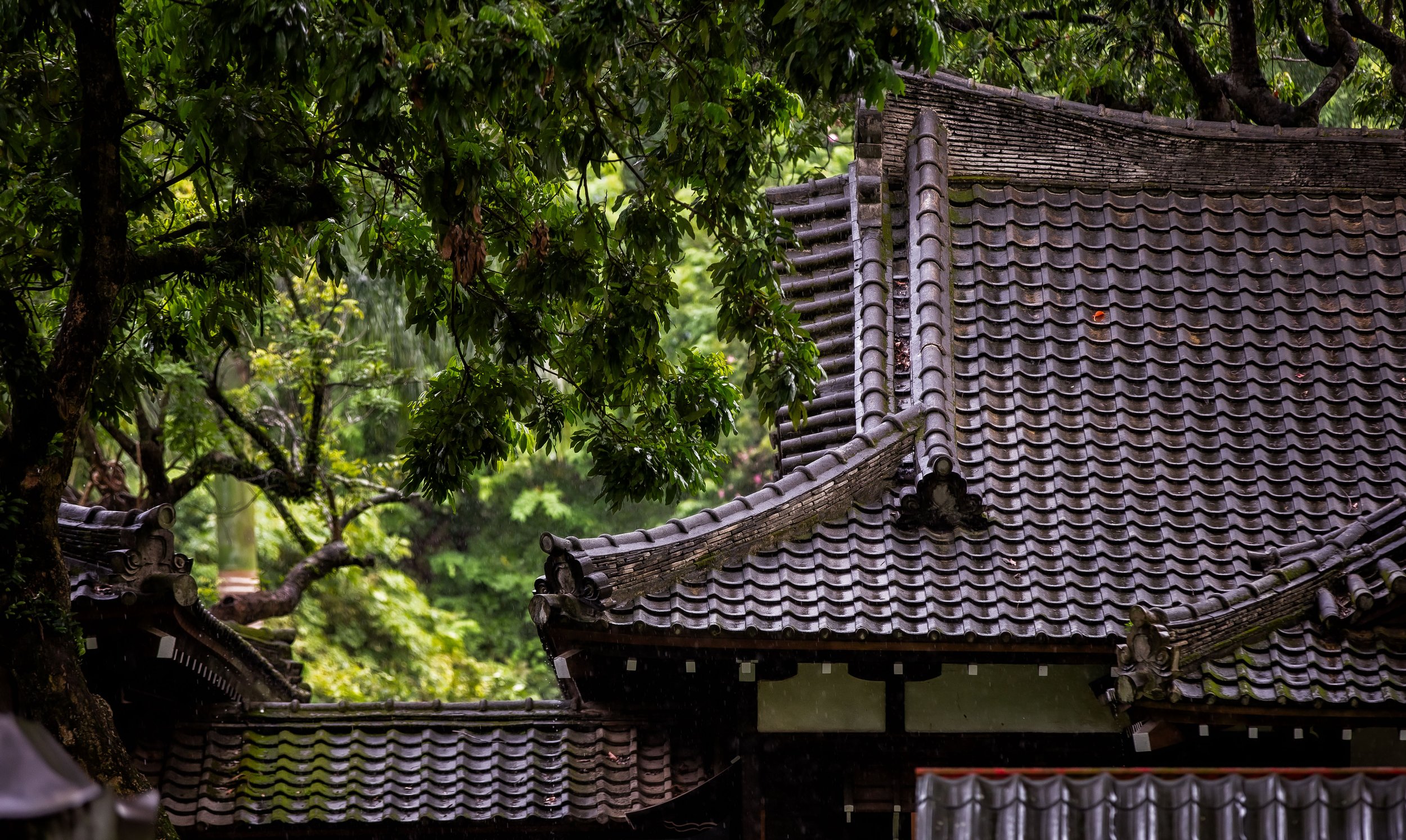
The first thing you’re probably going to notice about the temple is its intricately designed roof, which may seem like a common design in Taiwan, but don’t let the fact that this style is so prevalent here distract you from how amazing they are - The people of Taiwan have expertly preserved this culturally-rich style of architecture, which is important because in neighbouring China, it has (in many cases) become a distant memory.

One of the most prominent features of Hokkien architectural design is the Swallowtail Roof (燕尾脊), which has an upward-curved ridge shaped like the tail of a swallow. In the case of this temple, the ridge is split into two different sections with the lower section curving at a much higher degree than the upper section. The roof is also adorned with porcelain carvings (剪瓷雕) of historic figures, mythical creatures and flowers.  

The front facade of the temple is beautifully designed and the recent paintings of the door gods and the murals are quite colourful. As this is a temple dedicated to the Goddess Mazu, you won’t find stone guardian dogs at the entrance. Instead there are Stone Drums (抱鼓石) on either side of the main door. Above the drums, you’ll find two beautifully carved traditional wooden windows and above the door a plaque that reads “Tian Hou Temple” (天后宮). 

On the main doors you’ll find Qin Shubao (秦瓊) and his counterpart Yuchi Gong (尉遲恭), two popular generals from the Tang Dynasty, acting as door gods - Qin is the lighter skinned general who is carrying a sword while Yuchi has dark skin and carries batons. The two figures are commonly used as door gods thanks to a legend that tells of how they guarded the emperor from ghosts allowing him to rest peacefully.

On the Dragon Door (龍門), you’ll find a Eunuch (宦官) holding a peony and an incense burner while the Tiger Door (虎門) on the other side features a Palace Lady (宮女) holding a teapot. Both of these door gods are used to indicate that there is a royal palace on the inside. 

 In Chinese, they say “龍門進虎門出“ (lóng mén jìn hǔ mén chū) which means that you should enter a temple through the “Dragon Door” (龍門) and exit via the “Tiger Door” (虎門). The reason for this is because entering the dragon symbolizes ”praying for happiness” while exiting through the tiger is thought to “ward off bad luck or misfortune”.

It is essentially a symbolic way of purifying yourself before you enter a temple. If you however were unaware of the rules and you entered through the tiger door, it would be considered to be bringing misfortune both for yourself and the temple, and thats not a good thing. 

Likewise, the middle door (中門) is a space reserved for the gods or high-ranking government officials. If you’re wandering around a temple and you walk through the middle door, it could be considered bad luck because you’re blocking the view of the gods. 

So, if you want to enter a temple, you should enter through the ‘Dragon Door’, which is on the far right. If you want to leave the temple, you should exit via the ‘Tiger Door’ on the left and if you want to make the gods angry, just walk through the middle door and try your luck. 

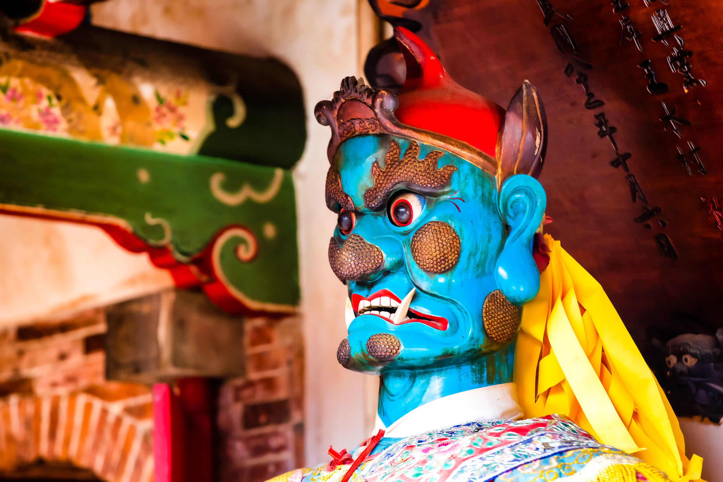
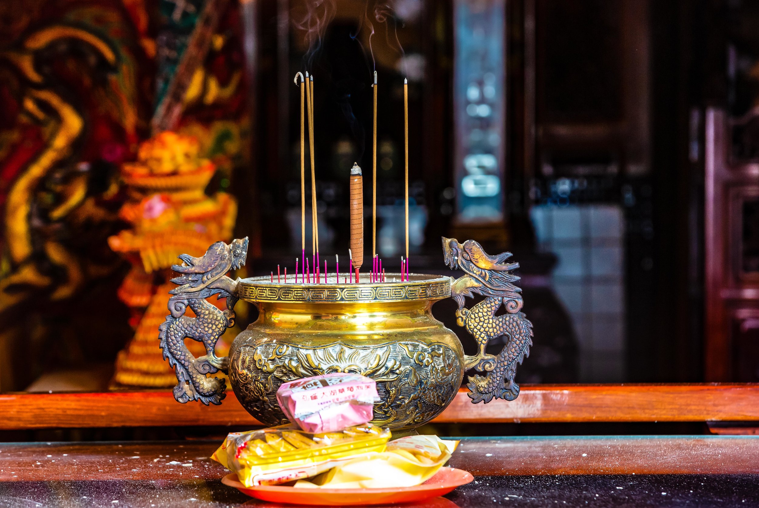
Once you’ve passed through the doors, you’re going to be met with a large table for offerings and beyond that an incense urn in the middle of the open-air courtyard. From there you’ll see the passage-ways on either side of the courtyard with larger than life statue-like figures of Qianliyan (千里眼) and Shunfeng’er (順風耳), or “Thousand-Mile Eye” and “Wind-Following Ear”, Mazu’s all-seeing and all-hearing guardian demons facing each other on either side.

Once you’ve passed by Mazu’s cool-looking, yet scary guardians, you’ll have reached the main shrine area. The shrine is split up into three different sections, dedicated to different gods. 

Left Shrine

The shrine on the left is dedicated to the Earth God who is known here in Taiwan either as ‘Tudigong’ (土地公) or Emperor Fude (福德正神). If there is any god in Taiwan who is as popular (or even more popular) than Mazu, it would be the Earth God. There are thousands of temples and shrines all over Taiwan dedicated to him. 

Middle Shrine 

The middle shrine is dedicated to Mazu and has a number of depictions of the goddess sitting within the closed off shrine. On the table in front of the goddess you’ll find an alternating group of folk-religion deities which seems to be different almost every time you visit. 

On either side of the shrine, you’ll once again find some statues of Qianliyan and Shunfeng’er protecting Mazu.

If you have good eyes, you might want to take a peak under the table at the main shrine to check out the ferocious Tiger General (虎爺) who adds another layer of protection for the goddess. 

Above the shrine you’ll see a plaque that reads “Prosperous Ocean Nation” (靈昭海國) - The plaque dates back to 1877 and was placed in the temple when the port of Xiangshan started bringing riches to the area

Unfortunately with the main shrine, you are not only blocked from approaching by a gate but the goddess is also shielded by a screen that doesn’t allow you to see her too clearly. There could be any number of reasons for this, but it is likely that the Mazu statues are quite historic and they are trying to protect her from thieves.  

Yes, there are weirdos in Taiwan who will steal statues of deities and sell them on the black market or hold them for ransom.

Right Shrine  

The shrine on the right is dedicated to the Goddess of Child-Birth (註生娘娘), who is a goddess that you’ll almost always find accompanying Mazu. The purpose of the goddess, I’m sure you’ve figured out, is to provide a bit of spiritual assistance with childbirth. 

Second Shrine Room

The adjacent hall is home to two separate shrines - The shrine against the wall is full of ‘Guangming Lanterns’ (光明燈) dedicated to followers of the temple. The main shrine in the room however is an interesting one with an odd collection of figures placed together. 

The first figure is the Martial (武) representation of the God of Wealth (財神) - This is the god you’ll want to pray to if you’re looking for wealth and are involved in travel, car sales, farming, fishing, military, technology, etc.  

The next figure is named Jiutian Xuannu (九天玄女), who is known as the “Dark Lady of the Nine Heavens” and is regarded as the Taoist goddess of sex, war and longevity. In this temple she appears in human form, but you’ll notice that she has a feather on her head - This is because she often transforms into a bird with a human face. 

The third figure is the God of Literature (文昌帝君), who actually is another one of Taiwan’s most popular deities. If you’re a student, you’ll want to visit him before you have an important exam. 

In front of them you’ll see a statue of the Taisui God (太歲星君) that represents the current year of the Chinese zodiac.

The placement of these gods might seem a bit random as they’re not commonly found sitting together, but given that we have the martial representation of the god of wealth, and the goddess of war, its safe to say that their placement serves a very important historic purpose as Xiangshan was once home to an important port during the Qing Dynasty and lots of economic activity took place in the area, which is a specialty when it comes to this trio.  

Getting There


Address: #191, Alley 420, Chunghua Road, Section 5, Xiangshan District, Hsinchu City. 

(新竹市香山區中華路五段420巷191號)

The temple tends to attract quite a few day-tripping visitors on the weekends - This is because it is a short distance from the historic Xiangshan Train Station (香山車站), Haishan Fishing Harbour (海山漁港) and the Xiangshan Wetlands (香山溼地), which are all included in a popular bicycling route along the coast for people wanting a bit of exercise and some time out of the city. 

If you’re planning on visiting the area and want to make use of public transportation, you can simply take the train to Xiangshan Train Station and from there either rent a bicycle from the vendors nearby or grab a Youbike and start your tour of the area.

It is important to remember though that not all trains stop at the station, so if you’re travelling south on the express train, you’ll have to get off at Hsinchu Station and transfer. Likewise, if you’re travelling north, you should get off at Zhunan Station (竹南車站) and transfer to a local train. Xiangshan Station is only a few stops away from both. 

If you have your own means of transportation, you could also drive your car down the West Coast Highway (西部濱海公快速公路), park it near the station or the temple and from there ride your bicycle up and down the coast.

If you are driving south though you’re going to have to pass by the temple, take the Xiangshan Exit and then double back to reach the temple. Make sure to copy the address above in Google Maps or on your GPS to map out the best route. 

If you’re not interested in riding a bike and don’t feel like checking out any of the other places of interest in the area, but want to stop by the temple, never fear, there is a large, free parking lot where you’ll be able to park your car or scooter. While you’re there though, I recommend at least climbing to the top of the elevated highway platform to check out the view of the beautiful Xiangshan Wetlands from above. 

The Xiangshan Tian Hou Temple may not be as large or as well-known as its Taipei, Lukang or Tainan counterparts, but in terms of its history and close relation to the local community, its importance cannot be understated.

While most of the other Tian Hou Temples in Taiwan are some of the nation’s busiest places of worship, activity at this one is a bit more subdued which if you ask me makes it much more accessible, affording guests the opportunity to enjoy all of the finer details.

If you find yourself in the Hsinchu area, you should definitely take the short train ride to Xiangshan Station and then make your way over to this historic temple.

There is of course quite a bit that you can do on a day-trip to the Xiangshan area, so if you want to get some exercise and enjoy some beautiful scenery, you should definitely consider stopping by. 


The Quiraing

If you’re an avid hiker, a trip to Scotland won’t disappoint - The country is highly regarded for its rugged mountainous landscapes and it seems that no matter where you are, you’re never far from a breathtaking trail. Even if you’re just hanging out in the capital city of Edinburgh, you can easily hike to the top of a couple of mountains that provide some really great views of the historic cityscape.

Scotland’s mountainous landscapes however are considerably more enjoyable the further you travel north - The sparsely populated Scottish Highlands for example, with boundaries that lie north-west of cities Glasgow, Stirling and Dundee, is an area considered by many to be the cultural heartland of the country and is home to several high mountains, including Ben Nevis, the highest mountain peak in the United Kingdom.

The Highlands are highly regarded for the well-maintained hiking trails, big open skies, whisky distilleries and the amazing people who live there. In fact, tourism figures indicate that over 95% of the foreign tourists who visit Scotland come for the hiking, with well over a million people trekking through the Highlands each year.

With around three-hundred ‘munros’ (mountain peaks) reaching over 3,000 ft, locals in Scotland have taken to referring to these adventurous tourists as ‘Munro Baggers’, which is a shout out to Sir High T Munro, who surveyed and catalogued all of them and started what would be the ultimate Scottish challenge - climbing all of them! 

Link: Scottish Munros and Munro Bagging (Visit Scotland)

If you’ve been considering a trip to Scotland, it’s likely that you’ll have noticed that one of the most common and iconic images of the area isn’t of a peak Ben Nevis or Ben Lomond - they are almost always of the breathtaking landscape of ‘the Quiraing’ on the Isle of Skye.

The Quiraing, which is considered to be Scotland’s premiere mountain hike is one that attracts tourists of all varieties as the experience of hiking the rugged, yet amazingly beautiful trail is one of the best experiences one can have while hiking in Scotland.

Coincidentally it is also the reason why the quiet Isle of Skye has become one of the world’s most popular tourist destinations in recent years.

The Quiraing

The Quiraing, or ‘A' Chuith-Raing’ in Scottish Gaelic is a popular hiking trail along the Isle of Skye’s northernmost Trotternish peninsula. The name ‘Quiraing’ 「KWIR-AN」can be a bit of a tongue-twister for most peoe to pronounce, but don’t worry if you make a mistake, the locals living on the Isle of Skye have heard it all and are happy to indulge you.

The Gaelic name for the ‘Quiraing’ actually originated from the Old Norse words 'Kví Rand' which loosely translates as “Round Fold” referring to the shape of the trail that reaches around the mountain. Historically the trail formed something of a protective barrier which local farmers used to their advantage to conceal their livestock from Viking raiders.

Today you won’t find many cows grazing along the trails, but you are likely to come across quite a few more mountain goats than you will people scattered throughout the trail. Fortunately they’re rather indifferent to your presence and they’re quite well-behaved.

The geologically significant Trotternish Ridge was formed during the glacial age due to a great landslip that occurred in the area. To explain things a bit more scientifically, basically what happened is that gravity forced the much heavier layers of volcanic rock in the area to collapse and dislodge the weaker underlying layers of sedimentary rock forcing a massive landslide.

The landslide, the largest of its kind in the UKs history was responsible for shaping the 19 mile long ridge and created not only the breathtakingly beautiful Quiraing but also the “Old Man of Storr”, another popular tourist destination.

The Quiraing area though stands apart from the rest of the ridge due to the fact that it is the only area that continues to remain geologically active. The landscape is in a constant state of motion and shifts at least a few centimetres each year requiring the roads to have to be repaired on a yearly basis. The result of this constant state of geological motion is breathtaking scenery, jagged rock formations, rolling hills, mountainous lakes and valleys that create a rich tapestry of some of the best landscapes this planet has to offer.

The Hike

So, how do you go about hiking one of Scotlands most iconic trails? Is it going to be difficult? Is it going to take a lot of time? Do you need to be an experienced hiker?

Let me answer those questions quickly: No, No and No.

Once you’ve gotten yourself to the parking lot, what you hike is up to you, how much you’re willing to walk and most importantly, the weather.

The full circuit hike that brings you from the parking lot, all the way around the mountain and back is about 6km in length. Most people however don’t elect to hike that far and instead prefer to walk far enough to get some nice photos and then heading back the way they came.

If you don’t plan on hiking the full loop, you don’t really have to prepare very much other than a camera and your smile. The trail along the mountainside is quite safe and doesn’t require much hiking skill or experience. You can walk as far as you like and then turn around when you think you’ve seen enough.

If on the other hand you plan to do the entire circuit, you’re going to have to prepare some water, snacks, proper footwear and (depending on the season) proper clothing. The full circuit starts out relatively easy, but becomes slightly more difficult once you’re halfway through.

Needless to say, if you’re not a fan of heights, this one probably isn’t for you.

The first portion of the hike follows a well-worn path along the mountain and provides an excellent opportunity for photos of the various crags, lochs and valleys below as well as Rona and Raasay islands in the distance.

the-quiraing-map-1300-7-.jpg

Once you start rounding the cliff, the view starts to change and the level of difficultly starts to increase as well. From this point on, you’re going to be walking mostly up hill with views of the northern coast until you reach the top and start walking down the other side of the mountain to the parking lot.

Even though hiking the full circuit is considered moderately difficult, you’re going to be glad that you made the effort as the upper portion of the mountain affords the most beautiful views of the Quiraing. You’ll also be able to enjoy 360 degree views of the entire northern coast of the Isle of Skye and the Scottish mainland in the distance.

If you hike the entire loop, local estimates indicate that the entire hike should take about two hours to complete - I can assure you though that you’re going to stop on numerous occasions to enjoy the scenery. The number of times you stop in addition to the amount of traffic on the trail are going to be factors in how long it takes you to complete the hike.

So if you really want to enjoy the beauty of the Quiraing, I’d suggest that you prepare for at least 3-4 hours.

I hope that if you’ve read this far, that you’re also able to learn from my failures.

I screwed up when I hiked the Quiraing and I’m a bit ashamed to admit it.

My first failure wasn’t really any fault of my own - The day that I had set aside for hiking the Quiraing fell on a day when the weather was absolutely horrid. We drove up the mountain, parked the car and there was nothing but thick fog, making the trail pretty much impossible to hike (or enjoy).

My second failure was caused by a lack of preparation - I didn’t do enough research into the trails to know how to complete the entire loop. I had assumed that the trail would be well marked and easy route to follow. Unfortunately when we had completed about 75% of the trail, we started feeling like we were lost and were worried that we would lose our light, so we decided to turn around and head back the way we came.

Even though the trails are for the most part well-developed, there aren’t any markers that indicate the direction you should be headed in. Once you round the cliff, the trail starts to become a bit less worn, harder to follow and you’ll come across fewer people. In fact, on the day we were hiking, we were the only people who were hiking the entire circuit, so once we started walking up the cliff face, we were completely alone.

I attempted to consult Google Maps and GPS coordinates while on the trail, but the lack of internet connection in the area became an issue. So, after walking up the cliff face and having no idea how to get back on the trail, we decided to turn around and head back the way we came, which was really unfortunate.

Considering the lack of markers along the trail, you may find yourself in a similar situation, so it is important that you familiarize yourself with the route before you attempt to hike the circuit.

Below is a map of the Quiraing walking route that you can save to your Google Maps.

Link: Stages of the Quiraing Hike (Isle of skye.com)

Getting There


Address: Quiraing, Portree IV51 9LA, Scotland

GPS: (57.6301177, -6.2781544)

Getting to the Quiraing is going to require a bit of effort on your part - Whether you’re travelling directly from Edinburgh, Glasgow or Inverness, you’re going to have to endure the terrible task of driving through several hours of the most scenic roads imaginable.

Sounds tough, right?

The reality of the situation is that if you really want to make the most of your Isle of Skye trip, you’re going to have to rent a car. Even though its possible to take a train and then hopping on a bus that will take you the island, once you’re there you’ll have trouble getting around if you’re relying solely on public transportation.

My Isle of Skye itinerary was an action-packed week of touring the island that would have been impossible to complete without a car, so I can’t stress it enough that if you really want to enjoy the beauty of Skye, you’re going to need your own wheels to get around.

Starting your journey to Skye from Glasgow is probably your best bet as you can easily get there by air or railway. The city is about a 216 mile drive away from the island and offers a multitude of options for car rental services, giving tourists the opportunity to shop around and find the right rental to fit your needs and your budget.

From Glasgow, you’ll make your way around the beautiful Loch Lomond and shortly after you’ll find yourself driving through the Highlands. The drive from there becomes quite simple but you’ll likely want to stop several times to take a break, take some photos or get some food.

One of those stops comes just before you reach the bridge that takes you from the mainland to the Isle of Skye. The picturesque Eileen Donan Castle has become a must visit location for any traveller visiting the area and is a welcome stop after driving through the mountains.

A rare photo of a Josh in the wild.

Once you’ve taken the bridge to Skye, you’ll follow the A87 highway all the way to Portree and then switch to the A855 which will take you up the north-eastern coast of the island. Upon reaching the small village of Staffin you’ll have to start paying attention to signage on the road that will indicate where you’ll make a turn that will bring you up the mountainous road to the Quiraing parking lot.

It is important to note that the road to the Quiraing isn’t the best - Its narrow, its steep, it is often in bad shape and in the peak tourist season, it is jam-packed with traffic. You need to be very careful while driving up and down the road and you’ll also have to be considerate of other drivers making sure that you yield to them allowing them to pass by instead of creating a situation where traffic is stopped completely.

The parking lot is free of charge and is quite large, but during the summer months, it can be quite busy. If you arrive at the parking lot and discover that it is completely full, it is important to remember that you absolutely must not park on the side of the road that takes you up the hill. Not only is it dangerous, it will cause traffic disruptions. 

If you aren’t driving a car, there is an infrequent bus service that will transport you from Portree to Staffin, but once you’ve arrived there you’ll have to walk several kilometres up the road to get to the trailhead. Once you’ve finished hiking, it is likely that you’ll have to wait a long time for a bus that may or may not come. From what I’ve seen, the buses on the island aren’t really to be trusted, so if you do elect to take the public transportation route, you may find yourself stranded, so be sure to have the number of a taxi company handy.

If you prefer to use public transportation, the link below will give you a better idea of what’s available and how to better plan your trip.

Link: Travel Tips (Isle of skye.com)

In recent years the Isle of Skye has been overrun by tourists - so much that the local infrastructure has been stretched to its limits and most landowners are becoming AirBnBs hosts or converting their property into private lodges. This has had an adverse effect on the local economy with many local residents of Skye unable to purchase their own homes or finding a place to stay.

While there are arguments with regard to the sustainability of the tourism industry on the island, it is important to remember when planning your trip that travelling to the Isle of Skye is not going to be cheap due to demand and a lack of places to stay.

The reward though, for those willing to travel the long distance to the island and pay the high prices for room and board is spectacular scenery and memories that will last a lifetime.

If you travel to Skye, this trail is likely going to be your number one destination, so I don’t need to tell you how much I recommend visiting. Make sure though that you take some time to hike the full circuit and enjoy the spectacular scenery. You won’t regret it.


Fort San Domingo (紅毛城)


A few months ago I was commissioned to take photos for an article, a sample forty-eight hour itinerary for people visiting Taipei for the Indonesian travel magazine, DestinAsian.

I couldn’t imagine only having two full days in Taipei - After more than a decade, I’m still finding new places and enjoying new experiences. It goes without saying that the article covered quite a few of the places I’ve already been to, but strangely there were a couple that were still new to me.

You might think its weird that an article describing places that people should see during a forty-eight hour trip to Taiwan actually took me, a travel photographer, over a decade to visit.

All I can say is, maybe I just don’t really have a thing for old forts.

I hail from Nova Scotia on the East Coast of Canada and grew up seeing forts all over the place - English forts, French forts, my neighbours snow forts, etc.

They just don’t really excite me very much.

Still, when you’re getting paid to take photos, you can’t really pick and choose what the client wants, so on an early morning, I made my way out to Tamsui to take photos of one of the area’s most important tourist destinations, the historic Fort San Domingo.

Geographically speaking, Tamsui (or Danshui) is actually a lot closer to where I live than Taipei is, but if you’re not driving a scooter or a car, its a bit of a pain in the ass to get there. If I drove a car, it would have taken about half an hour but with a bus to Taipei and then the long MRT ride, it ended up taking almost two hours.

Given the amount of time it takes to get out there, every time I’ve visited I’ve more or less stuck to the popular areas around the Old Street and the riverside. It’s also a bit embarrassing to admit that I was always under the impression that the fort was quite a distance away from the downtown area which prevented me from visiting.

Suffice to say, I found out that it is actually within walking distance from the MRT station.

Now that I’ve visited Fort San Domingo, I can honestly say that I regret not visiting sooner.

Not only should this spot be on the itinerary of every tourists visit to Tamsui, it is one of the few historic spots in Northern Taiwan that deals with Taiwan’s Western Colonial history.

History

With a history dating back to 1624, Fort San Domingo, both a fortress and consulate, has been one of the most significant locations (with regard to western trade) in Taiwan for almost four centuries. Over its long history it has been controlled by the Spanish Conquistadors, the Dutch, the Qing, the Japanese and the British before becoming a National Historic Site in the modern era.

With such a long list of owners, the fort also had a variety of names - Today we refer to it by its original name “Fort San Domingo” (聖多明哥城) but it has also been referred to as Fort Antonio (安東尼堡), Koumoujyo (こうもうじょう) and colloquially by the locals as Âng-mn̂g-siânn (紅毛城), which in Taiwanese Hokkien translates as the “Red Hair Fort”, a clever way of describing the ‘weird-looking’ Dutch people who came to Taiwan.

Coincidentally if you visit the fort today, it appears red in colour, painted that way to match the consulate residence next door, although I’d like to think that it was an ironic way of paying homage to the nickname the locals gave it.

Spanish Era

The history of a fort located in this area started with the construction of the original Fort San Domingo around 1628-1629. The Spanish, who had already established a colony on what is today’s “Heping Island” (和平島) in Keelung, sought to increase their land holdings and expanded by force into the Tamsui area which was already a popular trading outpost with Chinese merchants.

The original Fort San Domingo was constructed simply of clay, wood and bamboo polls but didn’t last very long. A few years after it was constructed, it was attacked and demolished by a group of angry locals who were irritated with the taxes levied on them by the Spanish governor.

In 1637, a year after the fort was demolished, it was rebuilt, but this time they instead used stone and raised the walls to over twenty feet making life for the over one hundred soldiers stationed inside much safer from attacks by local militias.

The locals unfortunately turned out to be the least of their concerns because in 1641 the Dutch started to show more interest in the region and weren’t really big fans of the Spanish hanging around.

After a couple of attempts (over a period of two years), the Dutch were able to kick the Spanish out of Taiwan. Before they did though, the Spanish demolished the fort out of spite, because they weren’t interested in sharing it.

Dutch Era

As mentioned above, the Dutch East India Company (荷蘭東印度工色) started to take an interest in the area in the mid-1600s with plans to expand their trade with the locals. First though they had to expel the Spanish from Tamsui and Keelung to ensure their monopoly on trade and the safety of their trade ships.

In 1642 the Dutch sailed into Tamsui harbour with a large naval and land force and laid siege on the fort for a period of three weeks. They then moved on to and eventually took the port at Keelung ending the short lived Spanish occupation of Taiwan.

Once the Dutch kicked the Spanish out of the area they moved quickly to secure their position constructing a new fort on the site of the original that laid in ruins. The new fort, named Fort Antonio (安東尼堡), constructed in 1644 is the historic site that you can still see today.

With 32 foot high walls made of brick and stone was home to over 80 soldiers who were stationed there to protect the area and ensure that the trade of deer skins and sulphur went smoothly.

A few decades later, In 1661, a naval fleet of over 200 ships, led by Koxinga (鄭成功) landed in southern Taiwan with the intention of expelling the Dutch and establishing a base of operations on the island. After a nine-month siege the Dutch were defeated and signed articles of surrender at their southern stronghold at Fort Zeelandia (熱蘭遮城).

Undeterred, they quickly signed a cooperation agreement with the newly established Qing empire in China and reestablished their Taiwan base of operations in Keelung and Tamsui.

Their stay however was short lived as they were unable to retake any of their former holdings in central Taiwan and revolts by the Basai Indigenous peoples (巴賽族) saw many of their properties burnt to the ground.

Under constant threat from the locals and being caught in the war between Koxinga and the Qing in the south, the situation became untenable and Dutch decided to abandon the fort and left Taiwan in 1668.

Qing Dynasty

From 1683 - 1867 the fort controlled by Qing government representatives stationed in Taiwan.

The Qing never actually took up residence in the fort but they constructed stone walls with four gates around the perimeter in order to fortify their position in case of attack.

During the reign of the Jiaqing Emperor (嘉慶帝), China got involved in several incursions with the French over territory in Vietnam. In response the French sailed to Taiwan and attacked in Tamsui and Keelung. Easily defeated, they soon realized that their coastal defense network in Taiwan was more or less useless so in the following years they constructed several fortifications in key economic hot spots to protect their interests.

None of that would really matter though because in 1860s, as a result of the Second Opium War (第二次鴉片戰爭), the Qing were forced to sign the Treaty of Tianjin (天津條約) ceding Hong Kong to the British as well as Fort San Domingo (among many other properties) which would be used as a trade consulate.

When the British moved in, the fort was in bad shape with moss and other stuff growing on the walls, so they decided to clean it up and paint the fort red. Later they constructed the beautiful residence next to the fort to serve as a consular residence.

Notably, British linguist Herbert Allan Giles, known for his creation of a romanized system for Mandarin, lived in the fort or a period of three years while conducting research on what would become the Wade-Giles system of romanization (威妥瑪拼音), which is still widely used in Taiwan today.

Japanese Colonial Era

When Japan took control of Taiwan in 1895, things pretty much stayed the same at the British Consulate. The office continued to conduct its affairs and thanks to the colonial governments development projects, was able to modernize the property with running water, a sewage system and electricity.

In 1930, the Japanese government listed the site as a National Historic Monument (史蹟名勝天然紀念物保存法) and conducted surveys of the site to ensure its preservation.

Modern Era

When the Second World War came to an end, the Japanese were forced to surrender control of Taiwan to Chiang Kai-Shek and the Republic of China. The British returned to Taiwan and re-opened the consulate in 1946 and even though diplomatic relations between the ROC and the UK broke off a few years later, the consulate remained open to maintain economic ties.

In 1972, the British moved out of the consulate and tried to sell the land to the local government which wanted to turn the fort into a public museum. The asking price for the land however was far too high and the government refused to pay. Instead of selling the fort, the British placed the it under the stewardship of the United States which would maintain the grounds.

When America established relations with the People’s Republic of China in 1979, they were forced to cut formal diplomatic relations with Taipei, which once again made the question of the ownership of the fort an issue. The British didn’t have much interest in continuing to argue with the government, so in 1980 they turned over ownership of the fort, which was then listed as a National Historic Site and plans were made to open it up to the public.

In 1984, after a period of restoration, the fort was opened and amazingly attracted more then 40,000 visitors on its first day of operation.

Ownership and operation of the fort was later transferred to Taipei County (Currently New Taipei City) in 2002, which came up with plans to renovate the park after years of tourism put considerable wear and tear on the grounds.

After being closed for a year the fort reopened again to the public in 2005 as part of the Tamsui Historical Museum (淡水古蹟博物館), a network of historic sites in the area that has a modest admission fee and provides access to each of the sites.

Design

The area that encompasses ‘Fort San Domingo’ consists primarily of two main buildings which include the fort and the former consular residence. The area however is set up a bit like a park with a nature area on the hill below the main buildings with some additional buildings setup that help tourists learn about the area and provides shaded rest stops for visitors to have some food or drinks.

Strangely though, the actual fort is often a bit of an afterthought for most tourists as they prefer to spend most of their time touring and taking photos of the beautiful Victorian-style mansion instead. And you know what, I can’t really blame them. As far as architecture goes, the consular residence is absolutely beautiful and is a rare sight in Taiwan - The fort on the other hand isn’t really that appealing to the eye.

Fort San Domingo (主堡)

The information you’ll received on site claims that Fort San Domingo is the oldest surviving historic building in Taiwan. I’m not sure how much I believe that, but I guess I’ll give them the benefit of the doubt on this one, because yeah, it is pretty old.

The fort, which was constructed on the top of a hill overlooks the mouth of the Tamsui River and was constructed in a strategic location allowing the people in the tower to have the ability to closely watch who was coming and going through the river.

The fort is square-shaped and is about 15 meters in length and 13 meters in height. The walls around the fort are about two meters thick and were constructed with the thought that they could withstand artillery attacks.

The two-storey fort used a mixture of stones and brick to strengthen the walls of the structure. The outside walls, which were originally painted white were painted with stucco and lacquer but was later repainted red by the British to match with the colour of the consular residence.

The interior of the fort consists of a few rooms, which used to house soldiers and later consular officials. There’s not much to see inside, but the people who run the site have added some exhibitions that let you learn about what life was like when the fort was once a military outpost.

Consular Residence (領事官邸)

The beautiful Victorian-style Consular Residence is where most tourists focus their attention while visiting the area. The large two-storey brick building, constructed in 1891 is considered to be indicative of British colonial style architecture but mixes in a bit of local construction techniques that help to shelter the building from wind and rain.

The exterior of the red brick building is beautifully designed with arches along the veranda that encircles the perimeter of the building and makes for some beautiful photos.

The interior consists of several rooms on the first floor that were used for consular affairs including offices, a large foyer, meeting room and dining room, etc. The second floor likewise consists of three large bedrooms and storage rooms that housed the consular officials and their families. The rooms are large and beautiful and are currently full of displays that educate guests on what life in the residence was like.

The residence was designed by a British architect, but the craftsmen who constructed the building as well as the bricks and other material used in its construction were all imported from Xiamen in China. Likewise, the fireplace and clocks in the building were also imported, but directly from England.

Unlike the fort, most of the rooms in the residence are open the public and there are informative displays in each of them that allow visitors to learn about the house.

If you’ve got time, I recommend checking out each of the rooms, then walking around the perimeter of the building and checking out the line of cannons that sit to the rear of the building in the area between the fort and the consular residence.

For a more detailed description of the design of the consular residence check this link: Tamsui Historical Museum - The British Consular Residence.

Getting There


Fort San Domingo is located a short distance from the main stretch of the Tamsui Old Street. If you are planning a day-trip to the area, I recommend first walking from the Tamsui MRT Station (淡水捷運站) to the fort, checking it out and then making your way back to the MRT station walking along the riverside. This way you’ll get to walk the entire loop and not miss anything.

There are of course a few places you could stop along the way including the historic Fuyou Temple (福佑宮), Tamsui Church (淡水禮拜堂), the Tamsui Red Castle (淡水紅樓) and the Tamsui Customs Officers’ Residence (小白宮) among others.

If you follow this route, you can easily leave the MRT station and walk straight down Zhongzheng Road (中正路) until you reach the fort - even visiting a few places along the way. Then when you’re finished you can explore the Old Street along the riverside on the way back.

For those who have their own itinerary in mind, the address for the fort is:

No. 1, Lane 28, Zhongzheng Road. Tamsui District, New Taipei City. (新北市淡水區中正路28巷1號)

If you prefer to save some time and take a bus to the fort, you can take either bus #836 or Red 26 directly from the Tamsui MRT Station bus terminal.

You should also note that Fort San Domingo is open on weekdays from 9:30-5:00 and from 9:30-6:00 on weekends. It is closed only on the first Monday of every month.

There is also a modest admission fee of $80NT that offers visitors access to Fort San Domingo as well as nearby Hobe Fort (滬尾礮臺) and the Tamsui Custom Officer’s Residence (小白宮).

You have the option of paying with cash or your EasyCard (悠遊卡).

After living in Taiwan for so long, it is hard to believe that it took an article about a 48 hour trip in Taipei to get me to this historic tourist destination. In retrospect that is something I regret, I should have visited much sooner. If you’re travelling in the Tamsui area, you should definitely take the time to visit as well.